National Aeronautics and Space Administration
Goddard Space Flight Center

Space Weather Action Center
Sunspot Regions
Extreme Ultraviolet Imaging Tutorial
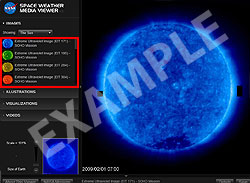
Above: Extreme Ultraviolet Imaging Telescope image of the Sun from the Solar and Heliospheric Observatory (SOHO) satellite. The above image is NOT live data.
Getting the Data
The easiest way to view this image is by opening the Space Weather Media Viewer. In the "IMAGES" section select "The Sun" from the small drop-down menu. Observe the first 4 images called, "Extreme Ultraviolet Image (EIT 171, 195, 284 and 304)". Don't forget to zoom in and pan to the lower left side of the image in order to see the exact date and time of the image.
About the Data
The first four images show images from SOHO EIT instrument (Extreme Ultraviolet Imaging Telescope)., EIT 171, EIT 195, EIT 284, EIT 304. EIT uses filters to allow the camera to record only particular kinds of ultraviolet light. Ultraviolet light is invisible to our eyes and has no color as we know it. These images are artificially colored to help scientists know what filter was used. So, just like in the visible spectrum red is the longest wavelength and blue is the shortest with yellow and green in between, the EIT image colors were chosen so that the longest wavelength is reddish and the shortest is bluish.
The bright spots in these images tell you that there is a lot of this kind of ultraviolet light being emitted. Dark regions show little activity. You should compare these four EIT images to each other and to the SOHO MDI images that show you where sunspots are. Try to determine if the active places (bright spots) in EIT images occur near sunspots. Use the Earth in the bottom right zoom box to help you determine the size of the area of bright spots by comparing the area with the size of the Earth.
Navigation Tips
At certain times these images will be inactive due to instrument recalibration and you will see the words "CCD BAKEOUT" over the EIT images. When this happens refer to the image called, "Transition Region and Coronal Explorer (TRACE)". It is important to note that these images are updated about every two hours. However, not all images are updated at the same time. This means that an image might be a few hours before or after others. You can download full size images and save them by clicking on the "Save" button in the lower right side of the viewer.
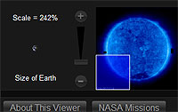
You can use the controls under the large box on the right to zoom and pan. This feature allows you to see the Sun in great detail. Some small active regions may not be visible until you zoom. The scale under the box on the right compares the size of the Earth with the image. When you click on any image in the viewer it will appear in the large box to the right allowing you to examine each image in detail.
You are viewing a tutorial
Related Tutorials
- H-Alpha Full Disk Image of the Sun
- Atmospheric Imaging Assembly
- Large Angle and Spectrometric Coronagraph
The above tutorials compliment the downloadable Flip Charts and Data Sheets.